Friday, 28 February 2014


Went for a ride yesterday. The weather was perfect. 
At the beginning I thought that I would avoid roads as much as possible and so I left town using bridleways. Unfortunately they were muddier and wetter than I had anticipated. I arrived at Shilley Green very bedraggled - my first 8km took forty minutes!
Once on the road my average speed (never much to boast about) increased rapidly.


Photogenic wet field.

Stevenage looking its best - ie from a distance.


I rode southwards and down in to the valley of the River Mimram. Ignoring a planned bridleway paralleling the river I instead climbed Tanyard Lane to the pretty village of Ayot St Lawrence.

Kimpton Mill, River MImram.


The new church. Obviously popular with visitors.

New church.


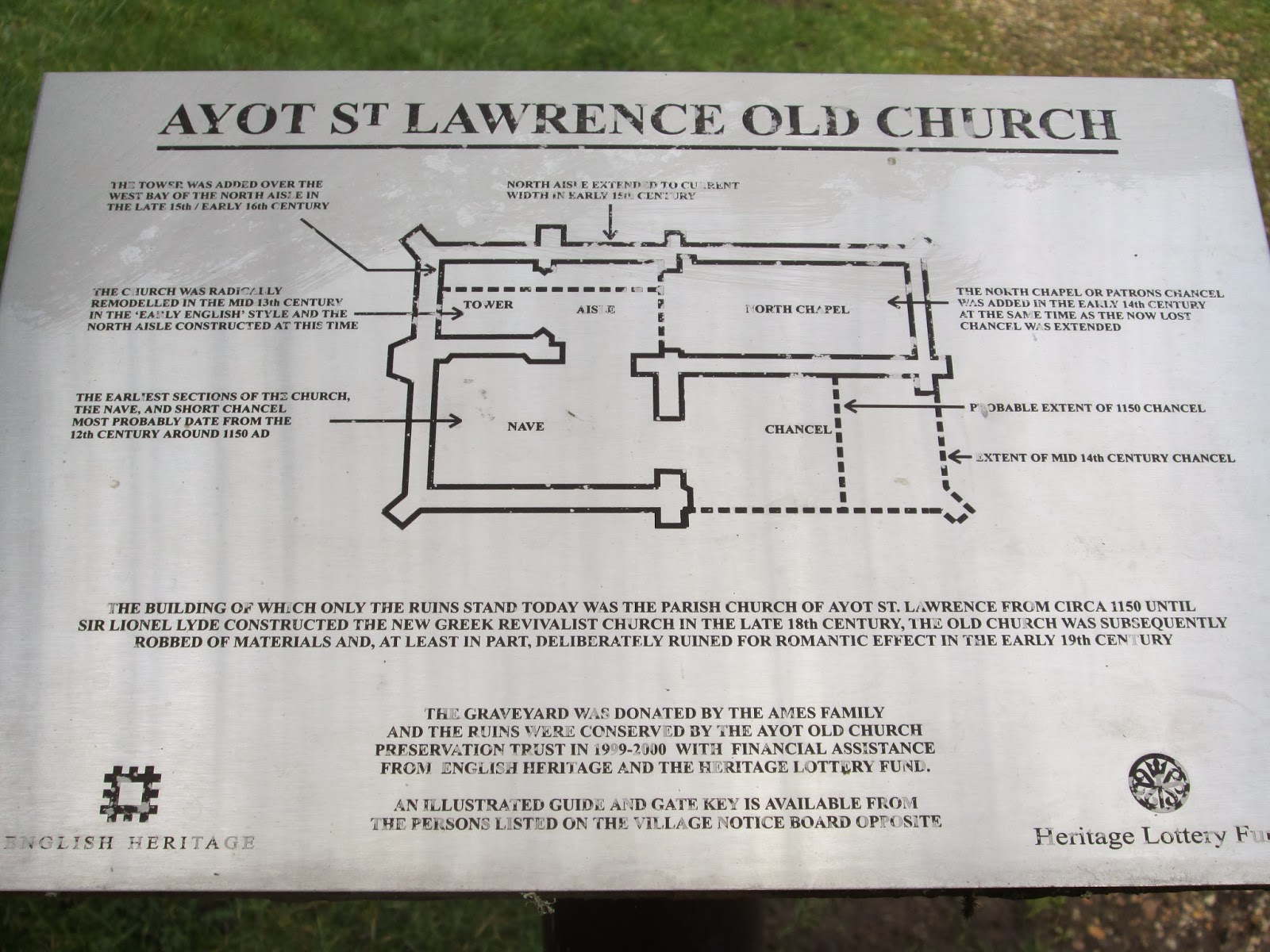
The mediaeval church is in ruins because the local landowner, Sir Lionel Lyde, decided to demolish it in 1775, because it was obstructing the view from his new home and he fancied something more 'modern'.
The arrogance of the rich and powerful never changes. That reminds me; the current MP is Grant Shapps.

I rode west out of the village and then southish through Gustard Wood, then began my ride home by looping back past Mackerye End. Here I passed a group of riders, all enjoying their retirement.


Mackerye End.


I decided to give the next bridleway a miss as it looked extremely muddy. However I then found myself on the noisy and busy B653, so I went straight on across Leasey bridge and up the hill. The road into Wheathampstead was just as busy as the B653. Oh well!


Anthills on Marshalls Heath nature reserve.

e


Wheathampstead.

I'll be there.


Views of Wheathampstead.


I sat at Wheathampstead's delightful restored station site to eat my lunch, then rode back along the Codicote Road and Brides Hall Lane to Ayot St Lawrence.


Ford over the Mimram.

Washed away bridleway on the hill up to Codicote.
I rode back to town via Tanyard Lane, Codicote, Nup End and Knebworth.

Rain over Stevenage.


Distance : 48km

Time : 4 hours

Effort : negligible (except while climbing Tanyard Lane and the 40m climb from Leasey Bridge).

Fun quota : high.


Wednesday, 26 February 2014

A Mouse's Tale.


I take food to work, but usually leave it in my pannier as this is more convenient for me except when the weather is very warm. Yesterday I left my sandwich in the bag in which the bread was packed, rather than using a lunchbox.
When it was time for elevenses I went out to my cycle, opened the pannier and out jumped a mouse. He had obviously been very busy as my sandwich looked like this:


Being a slow learner, today I used my lunchbox, but had a loose banana. 
Guess what I found when I went to eat it:


Sunday, 16 February 2014

Bimbling.


Yesterday I went for a short off-road ride despite, or because of, the wind. 
Today My wife and I walked to the nearby town of Letchworth, had an excellent lunch in Morrisons and returned by train.
We arrived at the station 15 minutes before the train was due, and could see it parked, waiting to come into service, a few hundred metres down the track. It still managed to be two minutes late. Well done First Capital Connect!

Anyway, here are a few Photos.


Makes a change to see a Hertfordshire ditch full of water.

Langley valley. Dyes Farm.

Edge of Langley Valley. That is DRY sandy soil. It was extremely windy up there.

Monument to E.M. Forster

Graveley pond.

Roxley Court, Willian. An estate cottage. Possibly the lodge.

Willian church and snowdrops.

Not Constable Country. Willian pond.

Village sign and The Fox pub (excellent food).

And finally!
Guess the guest celebrant at St Hugh's church in Letchworth.
Yes, the pope himself!

Friday, 14 February 2014

Cyclists - Outlaws in the Mediaeval Sense.

Anyone remember this term from school history lessons : caput gerat lupinum? 


Apparently it passed from English law in 1789, but I confidently expect the government to officially re-introduce it some time soon for non-motoring victims of motorists.

After all, recent court cases (which are a rarity in themselves) already illustrate its de-facto use as a legal principle.

Yesterday I fished out my cycling helmet from the shed and began wearing it while riding.
I have not worn it for several years. In a civilised nation I would not need to. However, in this third-world, morally bankrupt kleptocracy, even the minimal amount of protection it offers exceeds that offered to me by the law.

For a more carefully worded  explanation than I can give:

https://beyondthekerb.wordpress.com/2014/02/12/futility/#more-571

https://beyondthekerb.wordpress.com/2014/01/31/at-the-going-down-of-the-sun/

http://aseasyasridingabike.wordpress.com/2014/02/13/death-on-the-streets/

See also:
Helen Measures, Kenan Aydogdu - legally sanctioned killers.

Wednesday, 12 February 2014

First cyclist through the flooded underpass

Coming home from work today (Tuesday) I decided to try the flooded underpass, despite the barriers still being in place. I was in luck. The water has all been pumped away, leaving just a centimetre thick layer of slurry on the ground.  The walls tell their own story:


The high water mark can been seen near to the top of the photo. As you can see it was a double high tide like in the solent!

Saturday, 8 February 2014

Flooding.

On my way to work yesterday (Friday) morning my way was blocked by a flooded underpass on Hitchin Road. Although it was still dark, it was obvious that this route was completely impassable.
After work I returned that way to have a better look.It had been raining fairly persistently through Thursday night, but I was amazed at the volume of water; where had it all come from? I have never seen this underpass flooded before.
This is what it looked like:

Looking south from the shared footpath/cycleway (NCR12). The route follows the right hand side of the fence, straight into the water.


Looking north. The two black dots in the water just left of the lamp standard are the tips of wooden posts placed to keep users of motor vehicles from using this route.

Looking out across the flooded field.

The water in the underpass must be 2m deep.I assumed at the time that this enormous volume of water had something to do with the pumping station just out of shot - perhaps using the field as an emergency storage reservoir. However, once I reached home I saw lots of pictures on the internet of localised flooding in the Hitchin, Stevenage, Hertford area. I can only conclude that the land is now so saturated that all of Thursday night's rainfall remained above ground and just ran downhill until it could go no further.
Obviously I appreciate that these floods are insignificant compared to others around the country, but they are novel to me, living as I do in such a dry, well drained region.

Tuesday, 4 February 2014

Great North Road

As this ancient highway passes within just a few hundred metres of where I live, I thought that I would make some effort to learn more about it.

Most (all?) of its route has been by-passed from London to just north of here at Baldock, so it should be easy to access, on foot or by bicycle.

To begin with I just took a few photos. There are lots of leaves on the trees as they were taken in October.


Two shots of the Red Lion. My favourite Stevenage High Street pub, and a former coaching inn.

White Lion. Another former coaching inn. 


Two former coaching inns at the north end of the High Street. Now private residences.

Former farrier's. now a florist.


Looking south, then north along a section of the Great North Road now used as car parking for Stevenage Leisure Centre

The former (I'm using that word a lot) line of the road adjacent to the police station. As can be seen an underpass was built before this section went out of use.

This is Lytton Way which bypasses the Great North Road in the centre of Stevenage. Here the roads cross at an acute angle. The old road is in the dead centre of the picture behind the fence.

The famous Six Hills. They are thought to be Romano-British burial mounds.

And finally, at a fork in the road, the Roebuck Inn. To the right of the picture is the Great North Road leaving the town southwards on its way to Knebworth.  On the left is the road to Hertford.